Ever wondered who’s digging up your road or looking for signs of a FTTP full fibre roll out in your area?
Using free and public accessible data you can see historic present and upcoming roadworks in your area.
Local Authority website
If your interested in seeing all roadworks and or historical roadworks then the best place to start is by visiting your local authority website to see if they have an embeded roadworks map.
In my area Shropshire Council have one here
It is an embedded one.network map.
one.network is the biggest roadworks map across the UK and covers England, Wales and Scotland.
You can visit the main one.network site and you can sign up for a free account to see roadworks for the next 12 months.
The advantage of using an embedded map on your local authority’s website is the ability in most cases to look at historical roadwork events using the colander icon you can go back up to two months.
On the one.network site and embedded maps using the hamburger menu you can set filters as well as search for areas and set dates.
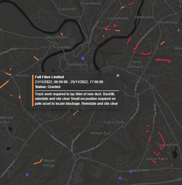
Each icon on the map represents the utility or event and clicking on each icon shows some details about the roadworks including :
Dates the permit is active
The company responsible for the permit/works
Location
Traffic Mangment; i.e traffic lights, stop and go boards.
Permit number.
works ref number
permit status
in some cases a description of the works.
Better Internet Dashboard
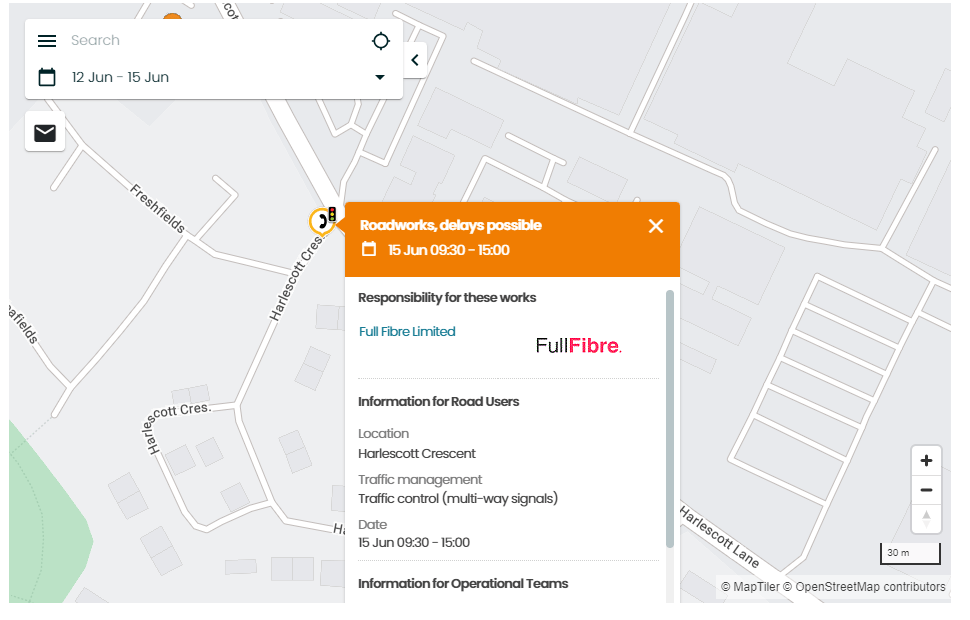
If all your interested in is roadworks relating to telecoms providers then a great website to use and one we recommend on our can i get full fibre page is the Better Internet Dashboard or bidb.
As well as beign able to check mutiple full fibre providers to let you know if any are live/planned in your area it also has an interactive roadworks map with just telecoms works.
When you put a postcode and housenumber in once loaded you will see future roadworks and a list of providers doing works in your area clicking on each of the companies logos on the right hand side will highlight their work which are all shown in different colours making it easy to see whos active in your area.
On the map clicking on one of the markings will show who is doing the work and in some cases a description of what their doing along with the permit status and dates.
The Description field is handy as it puts more context as to what said telecoms provider is doing.
For example you may see Openreach roadworks in your area and get excited thinking they may be starting to roll out full fibre but in fact the description may tell you their only replacing a defective pole/chamber which is less exciting.
Mast Database also has a roadworks map tailored for telecoms works and gets its data from the Better Internet Dashboard. I have found to have more success with getting descriptions on this site in my area so if you are getting no descriptions on bidb.uk in your area try on Mast Database.
On the ground
If you happen to be walking past a roadworks site in action then you should be able to find out who they are without reaching for your phone.
Each site must display an SLG board usually zip tied to a barrier and this should display:
The name of the company conducting the works
Permit number
Dates of the roadworks
Emergency contact number